

All maps from sources below (except Greenlee Gazette prediction), all dated October 19, 2008
I've been a registered Democrat only since the 2006 elections, but I've been voting for Democratic Presidential candidates since Bill Clinton ran against George H.W. Bush. I can thank Pat Buchanan's "culture wars" speech that year for the change. Before that, I was nominally a Republican, just like good old Mom and Dad (and Step Dad, and Step Mom).
In this jumble, I've had a pretty good track record picking Presidents. In 1984, at the tender age of 18, I voted for Ronald Reagan. Landslide victory. In 1998, I voted (tepidly) for George H.W. Pretty sizable victory there too. In 1992 and 1996 I voted for Bill Clinton, and while he won neither in a blowout (H. Ross Perot was in the mix), he still won pretty solidly. In 2000, things got a little murky, with Al Gore eking out popular vote win, and probably electoral too, though that will be argued for the rest of American history. And in 2004, I voted for John Kerry, which George W. Bush won in a squeaker--and I'll never be convinced that Ohio, the toss-up state, wasn't stolen. Never.
 So, as a two-time (sort of) loser in these things, I'm very, very leery of getting too excited about Barack Obama's apparent lead. Still, there's something a little thrilling about looking at some of these predictive maps. See, in 2000 and 2004, where "red states" and "blue states" were solidified in the public's minds as "GOP" and "Democratic", those final maps were awash with a large field of red in the middle, and some blue fringe around the edges.
This was parodied on several web sites as "Jesusland" or "Dumbf**kistan" in the middle, and America on the sides. I'm sure conservatives had a flipped version of their own. But even as intelligent people are aware that large numbers of people live in those blue states, and smaller numbers live in the red ones, it was disheartening to see that vast field of red. Oddly, in the mainland, the red was contiguous, and the blue mainly was too, just around the edges in clumps.
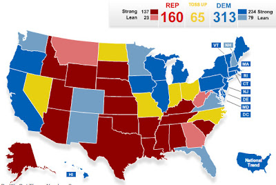
On all of the sites listed below, as I've followed them through the last couple of months, "Jesusland" has gotten smaller and smaller. Red states have switched to pink, to neutral, to light blue. Deep red states have gone pink in many cases. If viewed as an animation, you'd see blue pouring in toward the middle of the country from all sides, seemingly somewhat buffeted by the Rocky and Appalachian mountains.

On all of the sites listed below, as I've followed them through the last couple of months, "Jesusland" has gotten smaller and smaller. Red states have switched to pink, to neutral, to light blue. Deep red states have gone pink in many cases. If viewed as an animation, you'd see blue pouring in toward the middle of the country from all sides, seemingly somewhat buffeted by the Rocky and Appalachian mountains.
Red America (a term that is ironic and very funny to me) is still contiguous, excepting Alaska. But Blue America nearly is too. A stubborn slip of Idaho may be all that prevents them from meeting at the top. Georgia might surprise us, and link a strip through the south. New Mexico and Colorado probably have no hope of linking up with states around them, but who knows? Arizona could link it up in the southwest. This weary voter longs to see a little more thoughtfulness from voters. We've seen a lot of almost solid red fields on this map in the past (if you allow for revisionist colorization). It sure would be nice to see that map swallowed up by a sea of blue.
Below, just for the fun of it, are my best case scenario prediction, and my more realistic scenario. Absolutely no science involved, just guessing and (probably) wishful thinking. This is simply my pie-in-the-sky expectation, tempered with the realization that I could be wrong. A lot can change in two weeks. I'll follow up on November 5 (provided we know who the winner is this time) to see how I did. Well, unless I'm vastly off, in which case I'll be curled in a corner sobbing somewhere. . .

Resources:
No comments:
Post a Comment
Have something to say to us? Post it here!